Waterways
Venice is built on an archipelago of 117 islands formed by 177 canals in a shallow lagoon, connected by 409 bridges. In the old centre, the canals serve the function of roads, and almost every form of transport is on water or on foot. In the 19th century a causeway to the mainland brought the Venezia Santa Lucia railway station to Venice, and the Ponte della Libertà road causeway and parking facilities (in Tronchetto island and in piazzale Roma) were built during the 20th century. Beyond the road and rail land entrances at the northern edge of the city, transportation within the city remains (as it was in centuries past) entirely on water or on foot. Venice is Europe’s largest urban car-free area. Venice is unique in Europe, in having remained a sizable functioning city in the 21st century entirely without motorcars or trucks.
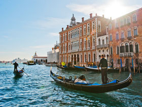
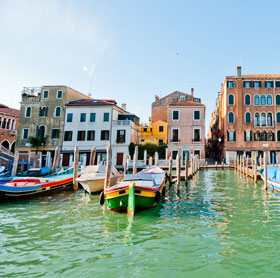
The classical Venetian boat is the gondola, (plural: gondole) although it is now mostly used for tourists, or for weddings, funerals, or other ceremonies, or as ‘traghetti’ (sing.: traghetto) to cross the Canale Grande in the absence of a nearby bridge. Many gondolas are lushly appointed with crushed velvet seats and Persian rugs. Less well-known is the smaller sandolo. At the front of each Gondola that works in the city there is a large piece of metal called the ‘ferro,’ or iron. Its shape has evolved through the centuries, as documented in many well-known paintings. Its form, topped by a likeness of the Doge’s hat, became gradually standardized, and was then fixed by local law. It consists of six bars pointing forwards representing the Sestieri of the city, and one that points backward representing the Giudecca).
The maze of canals threaded through the city requires the use of more than 400 bridges to permit the flow of foot traffic. In 2011 the city opened Ponte della Costituzione, the fourth bridge across the Grand Canal, connecting the Piazzale Roma bus terminal area with the Stazione Ferroviaria (train station), the others being the original Ponte di Rialto, the Ponte dell’Accademia, and the Ponte degli Scalzi.
Public transport
Azienda del Consorzio Trasporti Veneziano (ACTV) is a public company responsible for public transportation in Venice
Lagoon area
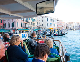
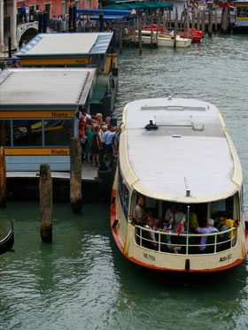
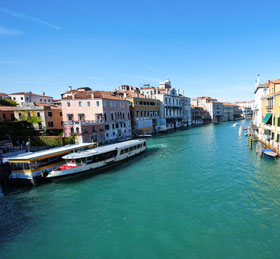
The main public transportation means are motorised waterbuses (vaporetti), which ply regular routes along the Grand Canal and between the city’s islands. The only gondole still in common use by Venetians are the traghetti, foot passenger ferries crossing the Grand Canal at certain points without bridges.
The Venice People Mover (managed by ASM) is a cable operated public transit system connecting Tronchetto island with Piazzale Roma. Water taxis are also active.
Lido and Pellestrina islands
Lido and Pellestrina are two islands forming a barrier between the southern Venetian Lagoon and the Adriatic Sea. In those islands road traffic is allowed. There are bus services on islands and waterbus services linking islands with others islands (Venice, Murano, Burano) and with the peninsula of Cavallino-Treporti.
Mainland
The mainland of Venice is composed by 5 boroughs: Mestre-Carpenedo, Marghera, Chirignago-Zelarino and Favaro Veneto. Mestre is the center and the most populated urban area of the mainland of Venice. There are several bus routes and one tramway line. Several bus routes link mainland with piazzale Roma, the main bus station in Venice, via Ponte della Liberta a road bridge connecting the historical center of the city of Venice, that is a group of islands, to the mainland.
Trains
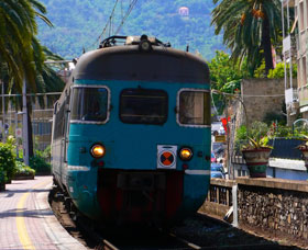
Venice is serviced by regional and national trains, which can connect the city to Rome in 3.5 hours and to Milan in 2.5 hours. Treviso is thirty-five minutes away. Florence and Padua are two of the stops between Rome and Venice. There are two main stations:
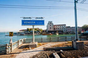
- the St. Lucia station is a few steps away from a vaporetti stop in the historical city next to piazzale Roma; it is a terminal station; the station is the terminus and starting point of the Venice Simplon Orient Express from or to London Victoria and Paris;
- the Mestre station is in the mainland and it forms the border between the boroughs of Mestre and Marghera.
Both stations are managed by Grandi Stazioni, and they are linked with each other by the Ponte della Libertà (English: Liberty Bridge) between the mainland and the island.
Others small stations in the municipality are: Venezia Porto Marghera, Venezia Carpenedo, Venezia Mestre Ospedale, Venezia Mestre Porta Ovest.
Airports
Venice is served by the Marco Polo International Airport, or Aeroporto di Venezia Marco Polo, named in honor of its famous citizen. The airport is on the mainland and was rebuilt away from the coast. From the Venice airport, it’s possible to reach by public transport:
- Venice Piazzale Roma by ATVO (provincial company) buses and by ACTV (city company) buses (route 5 aerobus);
- Venice, Lido and Murano by Alilaguna (private company) boats;
- Mestre, the mainland and Venice Mestre railways station (convenient for connections to Milan, Padova, Trieste, Verona and the rest of Italy) by ACTV lines (route 15 and 45) and by ATVO lines;
- regional destination (Treviso, Padua, beach, …) by ATVO buses and by Busitalia Sita Nordbuses (national company).
Some airlines market Treviso Airport in Treviso, 30 km from Venice, as a Venice gateway. Some simply advertise flights to “Venice”, while naming the actual airport only in small print. To reach Venice from Treviso airport people can catch a public bus from the company ATVO.
Venezia Lido, a public airport suitable for smaller aircraft, is found on the NE end of Lido di Venezia. It has a 1000-metre grass runway.